


Well after a BUNCH of work, I have managed to consolidate all of the SatSeries of apps (ProSat, HamSat, ISS and their iPad cousins) into a single universal application that provides access to different features via a subscription model. The "Classic" versions of the app will continue to be supported for defects through the end of the year but all new feature development will be focused on the new universal application.
So, head over to the new Satellite Tracker application (https://itunes.apple.com/us/app/satellite-tracker/id1438679383?ls=1&mt=8) to keep up on all the new features!
73,
-W0VOS aka Craig
--
If you are having an issue with any of my apps PLEASE drop me an email at [email protected]. There are a number of people who have left comments about the app not working but have never contacted me about the issue. At this point there are no known issues for the application and it is working as it always has.
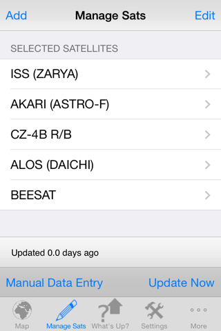
ProSat is designed to address the number one request in my website poll which was "ADD MORE SATELLITES" To that end, this is the Grand Daddy of the Sat series of applications (ISS, HamSat and now ProSat)
If you want access to the latest features (enhancements will show up here and then flow down to the other apps if at all) or you want to track more than the ISS or HamSats then this is the application for you.
This application contains all features of the other versions but adds in over 700+ satellites grouped into the following categories (from www.celestrak.com):
-100 (or so) Brightest
-Last 30 Days Launches (or so)
-Amateur Ham Radio Satellites
-CubeSats
-Disaster Monitoring
-Earth Resources
-Education
-Engineering
-Geodetic
-Geostationary
-GOES
-GPS Operational
-Intelsat
-Iridium
-Molniya
-NOAA
-Orbcomm
-Search & Rescue (SARSAT)
-Space & Earth Science
-Space Station
-Weather
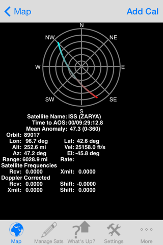
The application will calculate the rise/set times and associated azimuth and elevation for the selected satellite, Sun or Moon given either the user entered or network retrieved location.
There are two modes for satellite rise/set calculations. The first is for those folks wanting to know all overflights for a given location (like Ham radio operators) while the second mode computes only those passes where the satellite would be visible to a ground observer. In the ground observer mode, the calculations not only take into account that the ground is dark but also that the satellite is in sunlight (it even takes into account if the satellite becomes lit or unlit during the pass)
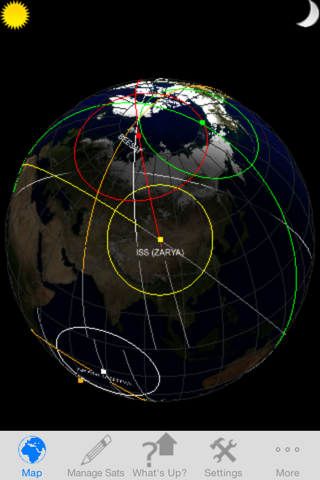
In addition, you can see the Earth rendered either as a 3D globe or a 2D map using photo realistic texture maps for the Earth model. The orientation of the map is easily changed by a simple rotation of the device from portrait (3D) to landscape (2D). In either orientation you can zoom in and out as well as pan using the touch screen.
There are more than a dozen controls provided to allow you to customize how the application works to meet your specific needs (type of Earth texture used, location, type of overflight calculated...)
Check out the Video QuickStart guide at http://www.youtube.com/watch?v=iuPccQI9oSg to see the app in action.
Thanks to everyone who has sent in their questions/requests and keep them coming!
-Craig ([email protected])